
A test alert will go out to the telephone numbers of all Laguna Beach residents at 10 a.m. next Tuesday, Sept. 24, from the city of Laguna Beach’s Alert OC system, which warns residents of emergencies affecting the town.
The test alert will verify the effectiveness of the mass notification system, which received its contact information from 911 data acquired from area telephone companies, said Jordan Villwock, one of the city’s emergency management coordinators.
In Laguna Beach, which has been hit by major fires, floods and landslides in the past two decades, the need for an early-warning system is evident, but a tsunami impact study released this month by the U.S. Geological Survey solidifies a new concern in local coastal communities.
Preparing for probable inundations from tsunami waves along the West Coast comes in the aftermath of the 2011 quake that propelled high-velocity tsunami waves in Japan. Due to that disaster, six independent teams of scientists studied the results of a simulated but “probable” 9.1 earthquake centered off Alaska’s coast and the potential resulting havoc along California’s coast, including Laguna Beach.
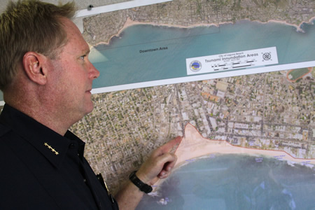
Laguna’s most threatened areas would be downtown shops and businesses near Main Beach, noted Villwock, also a police department dispatcher. Property on the sand at Bluebird Canyon Beach, Victoria Beach and Thousand Steps Beach as well as Aliso Creek State Beach and Aliso Creek Canyon are also in the risk zone, according to a USGS incursion map.
Heidi Miller, who rebuilt two downtown businesses after the 100-year-level rainstorm of December 2010, said she’s paying attention. “I’ve got more heightened awareness than I think most people do because I lost so much,” she said. “So anytime I hear about a tsunami and, of course, we’re five feet above sea level, it concerns me. When I heard about that, I thought, ‘What’s the next thing, locusts?’ If a tsunami was to hit, hopefully we’d have enough early warning that you may lose your business but you wouldn’t lose your life.”
Due to Laguna’s coastline, however, flooding from a tsunami would be minimal, extending less than a block, which would cover Main Beach with some spill-over across Coast Highway, said Kevin Snow, the city’s chief of marine safety. “If you’re on the sand, you need to move to higher ground,” he said.
A tsunami threat is near the bottom of the risk list in the city’s 455-page emergency management manual, particularly compared to fires and floods. Laguna’s south-facing beaches and coastal bluffs would buffer the wave impact in most areas, explained Villwock, adding that many ocean front homes in Laguna are 30-feet above sea level. “Laguna is definitely different from Newport Beach and Huntington Beach because of the way our shoreline faces; it’s not typically a direct hit,” he said. “The direct hit would be taken by Newport Beach mostly, depending on where the earthquake occurred, because of how their beaches face the ocean.” Sea-level homes on Newport’s peninsula and around its harbor would have greater risk, he said.
Laguna earned certification as tsunami-ready through the National Oceanic and Atmospheric Association, said Snow, which calls for public awareness campaigns about safety procedures, a public address system directed to beachgoers and well-marked evacuation routes. The point, he said, is to hoof it to the hills.
There’s another wave-flooding scenario worth noting, Snow said. “When there’s a local offshore earthquake,” he said, “if you’re sitting on the beach and feel strong ground-shaking and hear a loud ocean roar or see the water receding,” he said, “those are some signs where you should evacuate to higher ground.” Snow said there are no plans to build sea walls.
A tsunami, which builds from a distant epicenter, allows lag time to issue an organized evacuation warning, Villwock pointed out. Tsunami waves radiating from an offshore Alaskan earthquake could take up to six hours to reach San Diego, according to the USGS report. The local warning system can notify coastal property owners “within seconds,” said Villwock, who urged residents to register contact information at AlertOC.com.
Research shows a 60 percent chance of a 6.0 or higher earthquake in the area within the next 10 years, according to Villwock. “Experts say it’s long overdue,” he commented. “It’s hard to say how likely, but it’s definitely one of the hazards here in the city.”
The impact, according to scientists, depends on how the earthquake moves the earth, its strength and its distance. Tsunami waves are long, high-velocity, advancing, flooding and repetitive, and result from a fault line that causes the earth to undulate vertically, up and down, as opposed to a fault that moves horizontally, which does not cause the powerful tsunami reaction. The forces of nature, scientists agree, constantly seek balance and will create events that may be catastrophic to humans to reach that balance.
Tsunami waves can come from faults rimming the Pacific Ocean, called a subduction zone, that includes Alaska, Japan, the south Pacific, and even the west coast of South America, which has generated tsunamis that travel north, explained Charles Real, supervising engineering geologist with the California Geological Survey.
“If you can imagine a flat plate like a flat piece of wood in the bottom of the bathtub and you lift it, obviously the water’s going to lift up with it and it creates a wave,” he said. “That’s basically what’s happening on the ocean floor.” Real added that the local Englewood fault off the Southern California coastline is a horizontal fault line and does not produce tsunamis.
Tsunamis can build and repeat, even several hours later, according to the USGS report, but in southern California, the waves tend to attenuate over time. “The tsunami hazard from this scenario is generally less in southern California than elsewhere along the California coast,” the report stated. “However, some areas of southern California may be more vulnerable because of low-lying topography, larger coastal population and concentration of maritime assets.”
Southern California sits in a better position than its northern half, according to the USGS. “The shape of the California coast, bending east near Lompoc, causes the wave height of the tsunami (which approaches from the north) to be significantly reduced in southern California compared to the wave height in central and northern California,” the study reported.
Coastal communities will be alerted through the county sheriff’s department and will coordinate their emergency plans.
David Horne, a member of Emerald Bay’s independent Community Emergency Response Team as well as a member of Laguna’s Emergency Preparedness Committee, pointed out that it’s not just the strength and velocity of the wave, it’s the debris rushing with it. “All of a sudden, picnic tables are coming at you,” he said. He said 100 Emerald Bay residents are CERT trained, including 20 medical professionals. “If more people are prepared, everybody’s better off,” he said.
By comparison, interest in Laguna’s CERT program seems to be waning. With 70 CERT-certified residents, the September class to train more volunteers in emergency preparedness was cancelled. There were only six applicants.


[…] National Weather Service as a TsunamiReady city because of simulations such as this one as well as evacuation plans, signs and a notification […]