
By Rita Robinson | LB Indy
For the first time, Laguna Beach will have a continuous, marked north-south bike route through town, as unanimously approved by the City Council Tuesday. And it’s not on Coast Highway, where several pedestrian and bicyclist fatalities have occurred just over the past year.
Due to statistics that make Laguna Beach one of the state’s most dangerous small towns to ride a bike or walk, the Council also unanimously approved an 11-point plan intended to improve bicyclist and pedestrian safety.
The plan, considered a “start,” is the result of increased roadway fatalities, the number of drinking and driving violations and the amount of both drivers and pedestrians texting while navigating busy streets,
The points include increasing public awareness of traffic safety rules and signs cautioning motorists to slow down, share the road and not to text and drive. The city will also prepare a pamphlet on bicycle safety rules, which will be given to violators and distributed to sports shops and hotels.
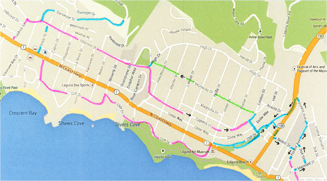
The safer bike route alternative to Coast Highway already exists in North Laguna starting at Ledroit Street on the inland side and Cliff Drive along the ocean. Indicated by sharrows, bike-and-arrow symbols painted on the pavement, the routes there will now merge at Lower Cliff Drive and wend their way through downtown Laguna via a myriad of marked streets to link with Glenneyre Street.
After navigating through downtown, a bicyclist can follow existing sharrows on Glenneyre to Caliope Street and then catch new sharrows on Glenneyre to Nyes Place. Or the cyclist can peddle hard over to Catalina Street via Park Avenue, where new sharrows give riders the right to occupy the lane on both sides of the road.
A non-highway route for cyclists will get new sinage.
A new “loop” will even take riders to Laguna Beach High School on Park Avenue following El Camino del Mar and Wilson streets and then up Anita Street to Temple Terrace and back down to Catalina via Mountain Road. All routes funnel riders to Glenneyre at Caliope, which eventually ends at Nyes Place.
From there, there is nowhere to go south except on Coast Highway. Connecting all the missing pieces in a town with difficult topography and adding the high school and Temple Terrace “loop” give bicyclists several options of designated shared roadway and the opportunity to leave their car at home while getting around town, according to reports.
The Council’s only objection to the route came from Council member Toni Iseman, who is seeking re-election in November. Iseman maintained that Glenneyre narrows to a one-lane road from Diamond Street south, where four speed bumps and speed limit signs of 15 mph slow traffic. She also said unwitting bicyclists will suddenly be caught riding a “diamond slope” where Glenneyre intersects with steep Alta Vista Way and Solana Way before ending at Nyes.
“You’ve got a one-way street, basically, where people take turns passing each other,” Iseman said. “I’ve been criticized because I don’t want bikes riding in front of my house. That’s not the issue. I just know the street.” Iseman suggested putting the route back on Coast Highway between Nyes and Diamond.
Billy Fried, one of four local residents and recreational bicycling enthusiasts who formed the Bicycle Working Group with city representatives to map out the new routes, disagreed with Iseman’s assessment.
Fried said the narrow part of Glenneyre “calms” traffic because of its width and speed bumps. “If you put them on Coast Highway,” he said, “you’re going to have another fatality.”
The new route links are intended to offer an option off the increasingly treacherous Coast Highway. It is the first contiguous, albeit crooked, north-south bikeway through town.
“When we start to implement some infrastructure to accommodate the bicycles, that’s really the only way we’re going to begin to reduce the conflict between the bikes and the cars,” said Max Isles, a member of the working group. “They’ve got to co-exist together. It’s not going to make Laguna Copenhagen but it is definitely putting a good foot forward.”
The Bicycle Working Group consists of residents Isles, Chris Prelitz, Tamara Hlava and Fried. Council member Kelly Boyd and Mayor Pro Tem Bob Whalen, City Manager John Pietig, Assistant City Manager Krista Johnson and Public Works Director Steve May complete the group.
The Council approved a contract of $8,000 with Fehr and Peers engineering firm to design the map outlining existing and new routes. Installing bike-route directional signs and striping will not exceed an already-earmarked $20,000 to install, a city report says.
Signs will mark the beginning of routes and where directions change. New sharrows will be painted in the middle of the lane 15 feet from an intersection and every 250 feet after that.
A dedicated northbound bike lane using the shoulder on the inland side of Monterey Drive in north Laguna will be indicated by green paint and shared with pedestrians and even right-turning vehicles, according to the city’s report. A short segment on Dartmoor Street will be added to connect cyclists to trails in the Laguna Coast Wilderness Park. Short segments on Broadway require approvals from Caltrans.
Additional bike racks and bike safety programs are also on the working group’s agenda
So Cal Bike Tour Avoids Laguna, Newport
By Rita Robinson | LB Indy
The death of a bicyclist on Pacific Coast Highway at Crystal Cove this past Sunday, Oct. 19, solidified the decision of a regional bike tour to avoid Laguna Beach and parts of Newport Beach as high-risk zones for safe bicycling.
Three bicyclists have been hit by cars and killed on Coast Highway between Laguna and Newport since August 2013. The latest fatality was Shaun Eagleson, 30, of Fountain Valley, the eighth cyclist killed in Newport since 2010, according to police statistics and other sources.
Laguna has also earned disparaging rankings as the most dangerous small town in California for pedestrian injuries and fatalities and 18th for cycling accidents, based on the state Office of Traffic Safety’s 2011 statistics, the most recent available.
Debbie Brubaker, tour director of Surf N Turf, a 241-mile bike tour from Santa Barbara to San Diego, said all it took was driving the route herself.
Before Sunday’s fatality, Brubacker, an avid cyclist who works for the California Biking Coalition, said she she had driven Pacific Coast Highway through Newport and Laguna to scout the route. “I don’t want to ride this road,” she said she remembers thinking. “It was a gut feeling. It made me uncomfortable. As beautiful as it is, it’s not as bike-friendly as other parts of the highway.”
The sold-out Surf N Turf starts Nov. 1 and is the inaugural bicycle tour of the California Bicycle Coalition, whose goal is to double the amount of bicycling in the state by 2017 in part by promoting safe biking routes. The bike safety advocates pushed the Complete Streets Act, passed and signed by Gov. Arnold Schwarzenegger in 2008. The law requires California communities to make roads accessible to pedestrians and cyclists as well as cars. The bike coalition also propelled the Three Feet for Safety Act, which went into effect Sept. 16 and requires motorists to remain a yard-length’s away when passing a bicyclist.
To avoid East Coast Highway at Crystal Cove in Newport Beach and Laguna Beach altogether, bicyclists on Day Four of the Surf N Turf tour will cruise from Long Beach to the Balboa Peninsula, take the ferry across to Balboa Island, cross to the Back Bay and detour to Irvine along the San Diego Creek Trail, said Brubaker. They will then follow Moulton Parkway, “a bike-friendly road,” she said, which changes to Golden Lantern and Camino Capistrano en route to Laguna Niguel, Dana Point and San Clemente. The route ends in San Diego on Nov. 5.
“Bicycling has almost doubled since 2000 in the state,” said Dave Snyder, CBC’s executive director. “It’s getting more popular and it’s getting safer. I would say Orange County is not keeping up with the rest of the state. Just look at the recent fatalities.”
Snyder said he’d like to route future tours through Newport and Laguna along Pacific Coast Highway if improvements are made. “There needs to be wider shoulders and protected bike lanes in order for us to do that,” he said. “And the speeds are too fast. It’s not safe to share the road there now.”
Green road signs that denote the Pacific Coast Bike Route along Pacific Coast Highway fall off in Newport and Laguna, said Brubaker. “The trail kind of disappears,” she said. “It’s not worth the risk right now until they make improvements and there’s definitely room for improvement.”
The five-day Surf N Turf fundraising tour costs $2,150 a person, which includes lodging and most meals. Proceeds benefit cycling advocates. Up to 30 bicyclists are expected to join the 16 five-day tour riders at any point along the route, said Brubaker. “There’s a lot riding on this, literally,” she said. “As tour director, we want to highlight the better routes. When you put a certain number of people out on the street, safety is the first concern.”


Have you ever seen so much colored ink on a bike map before? Ahh yes I remember now, it’s time for an election. Statistics show bike accidents and fatalities occur on PCH and LCR while the the city “approves bike-safety measures” for Monterey and Glenneyre, a minor detail.
“Public trust is good but control is better” -Lenin
[…] Beach riders get a new, continuous north-south route that avoids dangerous […]
[…] North-South Bike Routes Get Connected By Rita Robinson | LB Indy. For the first time, Laguna Beach will have a continuous, marked north-south bike route through town, as unanimously approved by the City Council Tuesday. And it's not on Coast Highway, where several pedestrian and bicyclist … Read more on Laguna Beach Independent Newspaper […]
[…] on Coast Highway here, Steve May, the city’s public work’s director, assured the council. The north-south bike route the city established, which parallels Coast Highway on secondary roads, will be the recommended […]