
By Rita Robinson | LB Indy
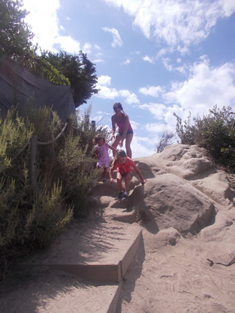
The steep and winding dirt footpath that joins a paved fire road between the two hilltop communities of Top of the World and Arch Beach Heights may soon be easier to maneuver for school children, moms with babies in strollers, dog-walkers, hikers, bicyclists and skateboarders.
The trailhead at Top of the World Drive connects to the fire road leading to Moulton Meadows Park and the Arch Beach Heights community, about a mile away. The City Council unanimously approved a plan last week that will keep the path where it is, running along the Sommet du Monde private community of six homes. But by adding a paved ramp closest to the homes and an adjacent stairway with a handrail on the outer edge, it will be less steep and safer for people walking or peddling.
Improving the trail has been an uphill climb, said City Manager John Pietig. “This is not easy,” he said at the council meeting. “This may seem like a simple little trail.” Peitig cited numerous difficulties, such as a myriad of issues with run-off and drainage, open-space encroachment, private use of city easements, street parking and sidewalk problems as well as steep trail grades, narrow sections and dangerous slopes.
“For the first time in a decade, I think we are close to being able to resolve these issues,” he said.
The newly approved plan calls for a 10-foot-wide easement compared to the current five feet. The path itself will be eight feet wide, Brown said, with a three-foot-wide ramp and a five-foot wide stairway. The stair and ramp combination will be used in two locations along the path.
“We have an existing public easement in that area that are on two properties,” Wade Brown, project director with the city’s public works department, explained at the meeting. “That easement goes through some tough terrain.”
The path will be made of concrete instead of dirt, “a solid surface with a lot of traction, like a boat ramp,” Brown said, that may also be pervious to prevent run-off.
Long-time resident Pam Berkson opposed the augmented trail. “It’s a hiking trail; it’s the hard that makes it good,” she said, citing the movie, “A League of Their Own.” Berkson suggested that the city use the paved road “that’s supposed to be used,” which now runs through the gated Sommet du Monde community and connects to the fire road. She said a concrete trail will only encourage mountain bikers to speed. “The bicycles are going to be sliding down that trail at even greater speeds,” she said, “knocking down the buggies, the dog-walkers and the walker-walkers.”
Public access to the end of the fire road was lost to the Top of the World neighborhood and elementary school when the Sommet du Monde community originated in the mid-1980s. The road became a private street and pedestrians were rerouted to the largely unimproved and, at points, treacherous dirt trail along an easement that skirts the properties. The gated road can be opened by automatic openers and manually by firefighters, police and city officials.
“I know you’re locked into this because you don’t want to fight the suit that the Sommet du Monde people would bring you,” said Jo Johnson, Top of the World resident. “You’ve got a lot of people trapped up there.” Johnson said she used a sledgehammer to break the lock to the private gate during the 1993 fire “so that people could get out that fire road.”
As it now stands, the steepest part of the trail is a 34-percent grade, sharper than the Third Street hill, according to city planners, with wooden and earthen steps originally built by an Eagle Scout troop and worn down by hikers and mountain-bikers and reconstructed several times.
The City Council’s decision on the trail’s future comes more than two years after the city contracted with Stantec design engineering firm of Irvine for design options. The city allocated $350,000 for the project, which is expected to be supplemented by a $125,000 grant for trail design from the California State Coastal Conservancy if plans are finalized by its February deadline.
“These are only sketches,” Brown reminded the council, adding that more city reviews and approvals need to be completed by Jan. 20 to qualify for grant money. Building the trail will be paid for by the city. The final price to complete the footpath project, including the street improvements, will probably exceed the initial estimate, according to the report.
Out of six trail sketches submitted by Stantec, the City Council chose alternative six because it was the least expensive, according to the report. As part of the project, the city plans to pave a portion of Top of the World Drive and add parking spaces and a sidewalk leading to the trail there.
Another alternative, which would have moved the trail away from the homes to a less-steep section of the park, was contingent on a $200,000 donation from Sommet du Monde homeowners. The offer did not materialize, Wade reported.
Jerry Sebag, a physician and eye surgeon who lives in Sommet du Monde, said through a spokesperson that he would contribute $20,000 to alternative 5 and up to $30,000 to improve the Top of the World Drive and sidewalk. Pietig said the street improvement offer is being finalized with the city and will be presented to the council in September.
Stantec received $91,000 for the initial report with architectural designs for the six alternatives. The Irvine architectural firm will receive another $62,000 to engineer the street improvements and create legal documents, as approved by the City Council.
“We got something done, woo-hoo,” commented Mayor Elizabeth Pearson after the vote. Pearson also thanked the Top of the World Neighborhood Assn. for “pushing for this for a couple of decades now.”
If deadlines are met and funds received, Brown said building the new trail could begin next May with completion sometime in July 2015.


[…] Council’s approval of a design in August and the Planning Commission’s conditional approval of the necessary permits for the project […]
[…] Council’s approval of a design in August and the Planning Commission’s conditional approval of the necessary permits for the project […]